
07/15/2026
Historic Wildfire Smoke Envelopes Southern Ontario
Extreme forest fire activity in NW ON, especially near Armstrong, has resulted in a massive smoke plume crossing the Great Lakes and drifting all the way to the Eastern Seaboard. Multiple airports in S ON recorded visibilities at or below 1SM, with some ashfall noted at London Airport along with some of the worst air quality readings in the province. The sun was largely blocked out, becoming a dim orange/red orb in the sky.
METAR CYXU 152200Z 35004KT 1SM R15/P6000FT/U FU VV018 26/16 A2999 RMK FU8 LGT ASH FALL SUN DIMLY VISBL SLP152 DENSITY ALT 2400FT=
07/10/2026
Surprise Supercell in SW Ontario on July 9th
Parameters seemed quite marginal for the overall severe thunderstorm risk in SW ON on July 9th, however a late afternoon outflow boundary caught my attention draped from the NNW-SSE across Lambton County. This boundary worked some magic as a developing storm near Sarnia latched onto it and began to turn more southerly. This resulted in an increase in SRH (storm-relative helicity) and caused the storm to develop updraft rotation and become a supercell near Brigden. The supercell went on to track towards Croton/Florence where it reached peak intensity and then morphed into a small bow echo near Highgate before continuing over Lake Erie. The storm exhibited a couplet on both Detroit and Cleveland radars and also had a notable hook echo. Damaging RFD winds snapped several tree limbs along the storm's track and produced a couple of gustnadoes.
07/05/2026
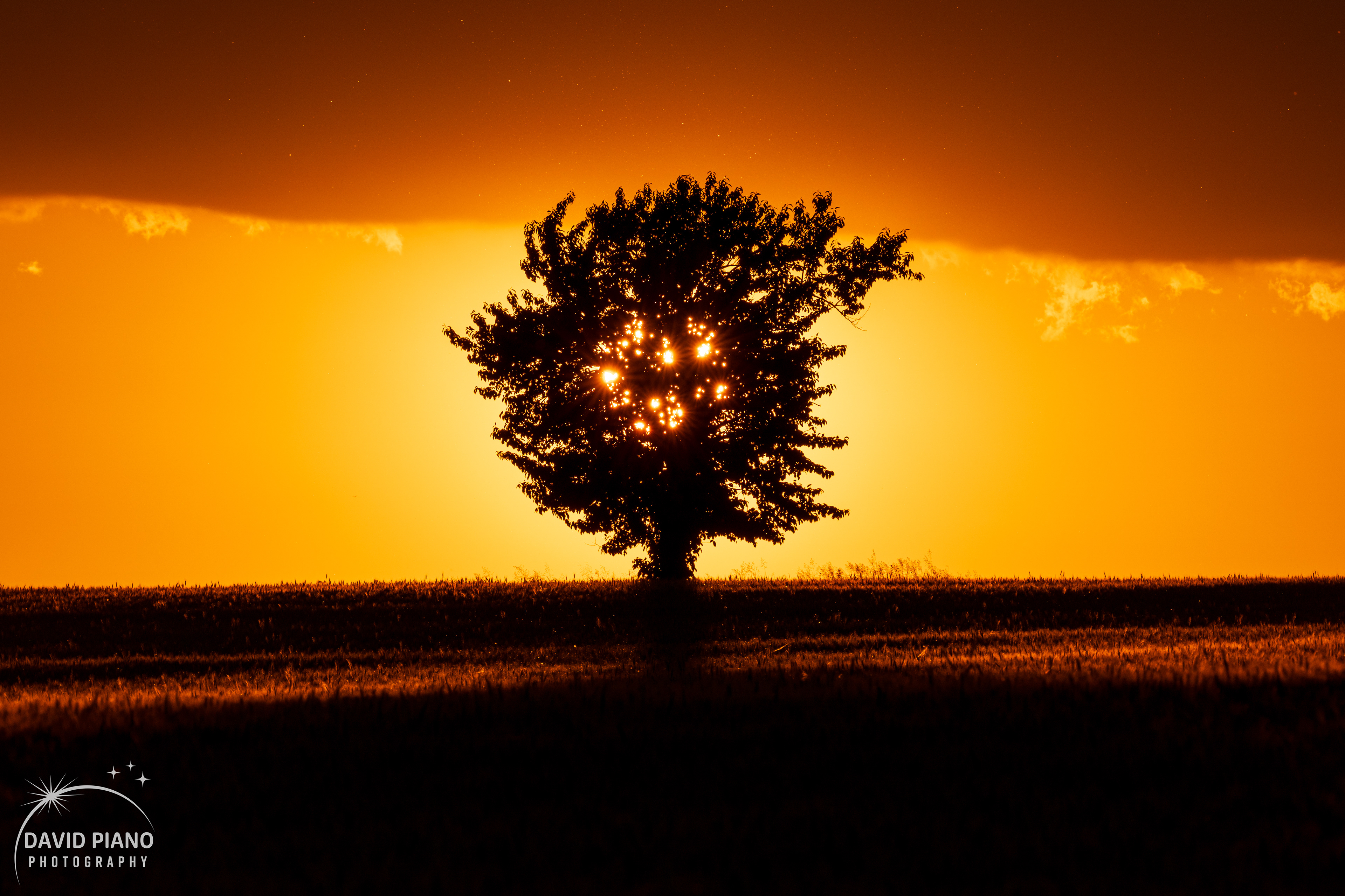
When pre-planning compositions yields big results...
Months of pre-planning were behind this shot. It all started when I noticed a beautiful lonesome tree while driving through the Oxford County countryside and came to the realization the setting sun must align nicely with the tree near the summer solstice. I began to imagine how I wanted to create this composition. What zoom / lens will I use? Where do I want to place the sun's disc? Do I want to use a narrow aperture (more in focus) or a wide aperture (blurring the foreground and background)? I pondered differing answers to these questions for a while, until the perfect opportunity arose on June 22nd. The NW horizon was clear but some lingering cumulus clouds from the day's strong heating stuck around until sundown. The clouds would give extra depth to the background and ultimately give the sense that the tree is connecting Earth and Sky. One question I never really settled in my head was where I wanted to place the sun. I soon realized I would place the sun directly behind the tree, as it created a dazzling effect, splitting the sun into several mini-suns filtering through the foliage. Insects taking flight over the field can be seen as little orbs of light over the tree. The tree's shadow draped across the field fills the foreground with darkness, adding exceptional contrast to the image.
My plans for photographic compositions often can be a bit overzealous, faltering in real-time when unexpected factors come into play. Every now and again, plans go well and the results come close to what I had imagined in my head. On extremely rare occasions, the result surpasses anything I could have imagined. This is one of those rare occasions where a truly special composition emerged from what I had been imagining several months before taking the photograph!
07/01/2026
Nature's Fireworks Display
Canada Day 2026 brought an extensive squall line across Southern Ontario, producing widespread wind gusts in excess of 100km/h. Tree damage and power outages occurred across a huge swath of the province, with over 200,000 customers without power in by the evening. I was on a weather obs shift at London Airport and took a direct hit by the gust front which produced winds in the 100-110km/h range lofting huge amounts of dust and breaking tree limbs in the immediate area.
06/29/2026
June 25th Storm Chase - Supercells in SW Ontario
A remarkable chase day in SW brought a couple intense supercells to a corridor between Sarnia and Port Stanley. An EF-1 tornado occurred near Glencoe and was on the ground for about 10km. While I missed the tornado, I tracked its parent supercell from Wyoming to near Alvinston across Lambton County. I watched the mesocyclone cycle several times with rotating wall clouds at the storm's base which produced several small funnels. I also encountered quarter sized hail and damaging winds with this supercell before bailing to catch newly developing cells to the west. While this move caused me to miss the photogenic tornado near Glencoe, I did end up on a new supercell near Dresden which I followed all the way to Port Glasgow on Lake Erie. This storm also produced severe winds but the big showstopper was the hail. I experienced the largest stones I have seen in Ontario, measuring stones up to golf ball size between Moraviantown and Highgate near the 401. At Port Glasgow, I watched the storm's meso track over the water with the edge of the hail core once again moving over me. Toonie to ping pong ball sized hail pelted the water like machine gun bullets. The chase ended with a spectacular double rainbow over Lake Erie and a wicked display of mammatus illuminated by the setting sun while the moon rose over the anvils of the retreating storms to the south.
06/13/2026
Overnight Chase North of London
Early Friday morning brought a fun storm chase north of London in the Wellburn area of Middlesex County. Despite models showing a squall line from Michigan rapidly diminishing in Ontario, it held on much better than expected with some segments even undergoing strengthening as it approached London. I found a nice vantage point with a grain elevator in the foreground and managed to capture some vivid lightning coming out of the front of a wall of cumulonimbus clouds as the storm approached. Wind gusts in the 60-70km/h range were experienced as I drove through the core.

05/22/2026
May 19th Storm Chase - Destructive Bow Echo & QLCS Tornado
An overachieving setup brought an intense close-to-home chase day for me on May 19 along the Middlesex/Oxford County line.
I began my chase near Thamesford where I intercepted a lead supercell in front of the developing bow echo which was in western Middlesex County at the time. I experienced downburst winds causing blowing dust and speeds in the 90-95km/h range along with a beautiful & turbulent whale’s mouth region beneath the surging outflow. As the storm moved east of me, a well-defined RFD cut and lowering/wall cloud was evident towards Ingersoll…and this supercell character was also noted in the radar imagery. I then dropped south on Putnam Road to just south of the 401 where I found a good west-facing field. This location was right under the outflow boundary left by the storm to the northeast…and I quickly noted a QLCS circulation on the leading edge of the advancing system with a good amount of dust being kicked up underneath and lofted upwards toward the cloud base. As it turns out, this was the long-track EF-1 tornado in the distance which NTP has recently released the track details on. The radar showed an appendage marking the mesovortex responsible for this tornado, and a velocity couplet was correlated as well. The tornadic circulation eventually broadened and the damage track ended just a few km west of me, however the parent mesovortex continued to pass JUST north of me. Suddenly, I was hit with damaging winds plastering the side of my Rav4 with mud and debris from the field. Several tree limbs broke off a few hundred feet in front of me. My anemometer measured a 114km/h gust despite being parked next to a grassy embankment about 5ft high which impeded the wind flow some…unobstructed 10m wind speeds over my location likely peaked in the 120-130km/h range. Post-chase review of footage and radar indicates I was on the SE flank of the mesovortex where an area of maximized wind was present at the surface with a direction from the SSW-NNE. My GoPro 360 cam picked up the rotating updraft associated with the mesovortex very clearly as it passed north of me while I was hit by the field debris. This was one of my top 5 most intense Ontario chases to date and my first tornado of 2026!
RADAR EVOLUTION
The radar evolution of the event is fascinating, as a transient supercell tracking out front of the bow-echo lasted all the way to Hamilton before being siphoned into the northern periphery of the bow. This same supercell was leaving an outflow boundary in its wake, also visible on radar near and parallel to Highway 401. This outflow boundary was being ingested into the updraft region on the advancing bow echo and resulted in an area of increased vorticity spawning the EF-0 QLCS tornado south of Nilestown/Dorchester. This was marked by a clear appendage on reflectivity and a correlated velocity couplet. A second appendage/couplet was ongoing simultaneously just south of Belmont. As the system tracked east, these two QLCS structures folded into the precip and weakened while the powerful bow echo surged forward with destructive winds across east Middlesex/Oxford Counties and eventually into Niagara Region.
04/16/2026
First big storm chase of the season!
Yesterday brought a wild start to storm season here in Southern Ontario with a wicked round of overnight storms (early Apr. 15th). A squall line and a separate cluster of cells out front both produced very frequent and intense lightning. A beautiful sculpted shelf cloud marked the leading edge of the squall line as it entered western Lambton County near 2AM producing some strong wind gusts to around 70km/h. The lightning in this event was interesting with widely varying colours from deep yellow/reddish flashes to electric blue flashes. I can't recall seeing such contrasting colours in quick succession as I did last night....very cool!

03/19/2026
March 3rd Lunar Eclipse: I watched the early morning lunar eclipse from Pinery Provincial Park on the shores of Lake Huron. Thick high level cloud made it impossible to see the blood moon during totality, however all of the partial phase was still able to cut through the cirrus clouds. A fantastic sunset also preceded the eclipse the evening prior. I have added a photo of the event to the "Other Eclipses" segment of my Eclipses page.
New pics from Rondeau Provincial Park have been added.
New Logo: I have decided to change things up and create a new eclipse themed logo. Not only is it well suited for the upcoming solar eclipse in August, but it also represents one of the most special natural events anyone can witness in a lifetime. The wonders of the natural world play a large part in the subject matter I seek in my photography and this new logo represents one of the best (if not the best) wonders I have witnessed to this day.

01/01/2026
As 2025 came to a close last night, I reflected on all of the awesome memories created throughout the year. 2025 featured a lunar eclipse, a beautiful naked-eye comet among several other amazing natural phenomena I got to witness. In September, I completed my longest and most challenging backcountry trek yet, tackling the Coastal Trail at Pukaskwa National Park. I hope to build on that accomplishment in 2026 and complete some more long distance backcountry trails.
Happy new year!

12/15/2025
Yesterday evening's drive home from work yielded a couple of wonderful atmospheric phenomena, light pillars and hoar frost! A cold airmass with high relative humidity created perfect conditions for ice crystals to form and become suspended in the air, causing the brilliant beams of light above light-sources on the ground. The high humidity and calm winds also allowed thick hoar frost to develop on trees resulting in an intricately beautiful display of nature's artwork!


11/20/2025
At the end of October, I was fortunate to have some clear skies to view 2025's best comet, Comet A6 Lemmon. I was able to piece together the most intricate and beautiful comet photograph I have ever taken using the knowledge and experience I have gained in the astrophotography field over the past couple years. The image consists of 140 thirteen second exposures stacked for a total integration time of just over 30min. The image was processed in PixInsight with some finishing touches added in Photoshop. It is truly remarkable how much additional detail is brought forth by stacking numerous exposures when compared to a single exposure used in the stack (see comparison below). I was fortunate to see the comet with the naked eye and bring out its true beauty with this imaging session. It won't be back in Earth's neighbourhood for another 1,350 years!
Furthermore, I am excited to share my new 500px account linked here and in the social icons across my site! This account will be a meticulously curated portfolio of my absolute best work.

Final stacked image (140 13sec exposures)

Single 13 sec exposure
10/16/2025
A long overdue update on my recent adventure in Pukaskwa National Park on Lake Superior...Over the course of 7 nights, I completed the Pukaskwa Coastal Trail from the south terminus (North Swallow Harbour) trekking northbound back to the Visitor Centre. The 60km journey was my longest and most challenging backpacking trip to date, however, spreading the itinerary over 8 days allowed for a leisurely pace and spending plenty of time at the spectacular backcountry campsites. I was also able to spend time composing a variety of photographs along the trail and at camp. The first few nights were clear and allowed for stargazing under a pristine night sky with no light pollution whatsoever. While numerous animals were encountered along the trail, the most interesting was a bear encounter at my Willow River campsite after dusk. Fortunately, it took off quickly after I turned my headlamp on it. That same night also brought the only rain of the trip in the form of a heavy downpour that lasted a couple hours in the overnight hours. Overall though, the weather was quite pleasant for mid-late September alongside the famously temperamental Lake Superior. After this equally challenging and rewarding trip, I am already eager to tackle another long-distance trail.
Here is a detailed break-down of each day on the trail:
Total distance logged: 71.04km
Day 1: North Swallow Harbour to Hideaway Lake
Distance logged: 5.59km
Day 2: Hideaway Lake to White Spruce Harbour
Distance logged: 7.64km
Day 3: White Spruce Harbour to Fisherman's Cove
Distance logged: 12km
Day 4: Fisherman's Cove to Fish Harbour
Distance logged: 15.51km
Day 5: Fish Harbour to Willow River
Distance logged: 11.28km
Day 6: Willow River to Hook Falls
Distance logged: 7.64km
Day 7: Hook Falls to Playter Harbour
Distance logged: 6.43km
Day 8: Playter Harbour to Visitor Centre
Distance logged: 4.95km
05/17/2025
In lieu of cancelling my plans to visit Tornado Alley this Spring, Ontario's storm season has gotten off to a decent start. Back on April 30th, I intercepted a severe thunderstorm on the west side of Ingersoll with 90-100km/h winds. In the early hours of May 16th (3AM), I chased a nocturnal squall line event that gave an impressive lightning display and shelf cloud just SE of London.
You can find photos from these events added to my 2025 Ontario Thunderstorms page.

01/02/2025
As I took some time to reflect on my favourite moments of 2024, I realized just how much it became the “Year of our Sun.” From the spectacle of the April total solar eclipse to the magical displays of auroras across the globe and a naked-eye sungrazer comet, the Sun played a crucial role in the most memorable events of the year. I won’t ever forget being left in awe with family & friends on the sandy beach of Point Pelee as totality swept overhead.
Apart from the astronomical events 2024 blessed us with, I also had the privilege to once again visit Tornado Alley in May with many spectacular storms seen rolling over the Great Plains, and to visit the stunning natural areas of Washington State. My time in Washington included some of the best backcountry campsites I have ever been lucky enough to experience.
I now look forward to what 2025 will bring. In February I will be visiting Sedona & the Grand Canyon but the rest of the year remains up in the air in terms of what trips / experiences I will embark on. Looking forward to whatever opportunities come my way!
Cheers to welcoming 2025!

07/07/2024
A few big updates to share....
First, my image gallery from my recent trip to tornado alley is now up and ready to view here.
Second, my images from the historic G5 extreme geomagnetic storm back on May 10th have also been uploaded and can be found over on my Northern Lights page.
2024 continues to be filled with awesome adventures, and I recently got back from a canoe trip into the Algonquin interior which featured some spectacular stargazing. Check out this photo of the milky way core shining over Manitou Lake!

05/03/2024
If you haven't had a chance to check out my images of the April 8th solar eclipse, they have been added to the Solar & Lunar Eclipses page.
I have a selection of fine-art eclipse prints ready to be shipped available at the following link:
04/15/2024
It's hard to believe the Great North American Eclipse of 2024 is now 1 week behind us. The weather panned out well for a good portion of SW Ontario, allowing stunning vantage points along the coastline of Lake Erie. I experienced the eclipse from Point Pelee National Park along with family and friends and was completely awestruck when totality swept over the calm waters of Lake Erie. Several large red prominences were visible to the naked eye and a 360 degree sunset effect painted the horizon in all directions. When the second diamond ring marked the end of totality, cheers echoed down the beach as onlookers marveled at the great celestial sight they had just witnessed. I will be adding my April 8th eclipse photos to the site shortly once I have completed my final couple of composite images. Prints will be made available and ordering information will be posted soon!
03/08/2024
We have reached the 1 month countdown window till the Great North American Solar Eclipse of 2024! This eclipse will be a once in a lifetime celestial event for many, as the next total solar eclipse to grace the skies of Southern Ontario won't occur until the year 2205!
Within the 10-14 day window before the eclipse, we will be able to start to see trends in the global long range weather models in regards to the overall pattern setting up for the April 8th timeframe. At about the 4-6 day window, it will then be time to start analyzing medium-range guidance for cloud cover prospects along the path of totality. I will likely make my decision as to where I am heading for the eclipse about 4 days prior. My hope is the north shore of Lake Erie experiences clear skies, but I will have many backup plans including heading out to Atlantic Canada.
Here is a fantastic resource to check eclipse times and info for your specific location or for your planned viewing spot:
02/14/2024
Solar Eclipse Practice Begins!
During a recent stretch of gorgeous February weather, I was able to put my new solar filter to the test. I purchased the filter in anticipation for the upcoming total solar eclipse on April 8th and plan to use it to capture the partial phases of the eclipse. The filter attaches to my Sigma 150-600mm telephoto lens and allows me to capture close-up detail of the solar disc. Below is my first test shot which captured many sunspots in great detail!

01/01/2024
Welcome to my new site! This space will be used to showcase my best photographic work and will be updated frequently with new content. With plenty of collections to browse, there are a great variety of locations and subject matter represented in my photography with something to please everyone. I have had the privilege to visit many spectacular places across North America and travel to see the most powerful storms on Earth. It is my passion to capture these experiences in my photography. I hope you enjoy browsing my portfolio and check back often!